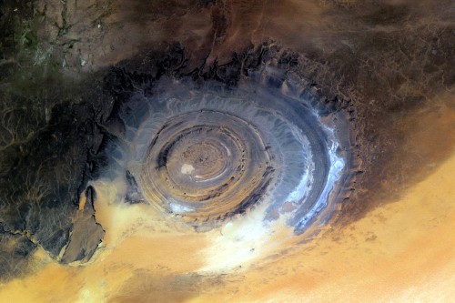
Last week I posted a couple of photographs of Cyprus from space. While looking through the rest of the images in collection, I noticed something that I’ve never heard about before – a picture of so called Richat Structure.

If you, like me, haven’t heard about it or heard and totally forgot, here is a brief Wikipedia summary that should get you started.
The Richat Structure, also known as the Eye of the Sahara, is a prominent circular feature in the Sahara desert of Mauritania near Ouadane. It has attracted attention since the earliest space missions because it forms a conspicuous bull’s-eye in the otherwise rather featureless expanse of desert. The structure, which has a diameter of approximately 50 kilometres (31 mi) and is located 400–450 metres (1,310–1,480 ft) above sea level, has become a landmark for space shuttle crews.
Initially interpreted as a meteorite impact structure because of its high degree of circularity, it is now thought to be a symmetrical uplift (circular anticline or dome) that has been laid bare by erosion. Paleozoic quartzites form the resistant beds outlining the structure. The lack of shock metamorphism at the site further backs the latter claim.


