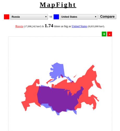
MapFight is a fun little web application, which superimposes the maps of two selected countries to show which one is larger and by how much. And the best part is that you don’t even to stick just to countries – the continents are in there as well, so you can compare Europe to Asia, or even Russia to Europe.
Tag: geography
Quora: if programming languages were countries …
“If programming languages were countries, which country would each language represent?” over Quora is hilarious! Here are a few bits to get you started:
C – Russia. Everything has to be done in a backwards way, but everything is possible, and there’s a lot of legacy.
C++ – USA. Powerful, but more and more complicated, unreadable, error-prone. Tends to dominate and influence everything.
Haskell – Monaco. Not many people, but very rich, so they don’t have to consider lower classes’ problems.
Java – Sweden. Comfortable, but has its own king and currency.
JavaScript – China. Developing really fast and can do lots of surprising stuff. A lot of users.
PHP – Bangladesh. Poor, but numerous, and it’s found all over the web.
Pascal – Germany. Strict rules, good performance. And there are many people who just don’t like the language.
Bash – Switzerland. Not very big in itself, but pulls the strings of the others.
Awk: North Korea. Stubbornly resists change, and its users appear to be unnaturally fond of it for reasons we can only speculate on.
Battle scars: How the first world war changed the world
Battle scars: How the first world war changed the world
Geography changed too. After the war the Treaty of Versailles carved out new countries from what remained of the old pre-war empires. Independence was granted to the Baltic states, which had been handed to Germany in 1918 as part of the Treaty of Brest-Litovsk, which ended Russian involvement in the first world war. Poland was reconstituted from former Russian, German and Austro-Hungarian territories, and Czechoslovakia, Yugoslavia and a larger Romania were created.
Check the link for the cool swipe map overlay.
Kiribati
In June 2008, Kiribati officials asked Australia and New Zealand to accept Kiribati citizens as permanent refugees. Kiribati is expected to be the first country in which all land territory disappears due to global climate change. In June 2008, the Kiribati president Anote Tong said that the country has reached “the point of no return”; he added: “To plan for the day when you no longer have a country is indeed painful but I think we have to do that.”
As sea levels continue to rise, the government of Kiribati is negotiating a deal with Fiji to evacuate the entire population to areas of Fiji that the Kiribati government would buy. The area of Fiji proposed for resettlement is the second largest Fijian island of Vanua Levu. The mass migration is expected to include younger, skilled workers first, and then the rest of the population would follow over a period of years.
Via ma.tt.
A lesson in geography perhaps, Mr.President?
Cyprus Mail does an extensive coverage of the explosion investigation (several articles, I’m only linking to the one I quote). The President of Cyprus, Dimitris Christofias, was also questioned and gave a few statements. Some of his words are rather unbelievable.
Christofias also denied it was him who decided where to put the munitions, adding that he had never visited the Evangelos Florakis naval base at Mari, which neighbours the Vassilikos power station, before the blast. “If I knew the proximity to the power station I would not have accepted them being stored there,” Christofias said.
Say what? I mean, I can understand that Cyprus is covered with villages big and small, some with duplicate names. But this place is special. It is the largest naval base in Cyprus. And it has the power station that was responsible for about 60% of all power supply. This location must be on every single strategic plan this country has. This should be one of the things you know before you accept the responsibility of leading this country. EPIC FAIL.
